Greater Melbourne and urban zones
Check map areas, boundaries and urban zone descriptions.
Key information
Primary production (farming) land may be exempt from land tax. There are different requirements depending on whether land is in greater Melbourne or an urban zone.
Greater Melbourne
Greater Melbourne is the area within the Urban Growth Boundary.
For land tax primary production exemption purposes, greater Melbourne is the blue shaded areas in the map below. This boundary took effect from 18 June 2014.
View a larger copy of the current greater Melbourne map
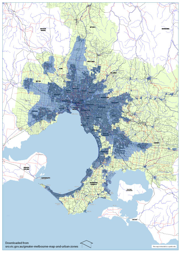
Map legend
- Blue: Greater Melbourne, which is the area within the Urban Growth Boundary is made up of some complete council areas and some partial council areas.
- Green: Not greater Melbourne. Some councils have land both inside and outside the Urban Growth Boundary. The green areas denote land under these councils falling outside the Urban Growth Boundary and therefore outside greater Melbourne.
- White: Council areas wholly outside greater Melbourne.
Complete council areas
These council areas are wholly inside greater Melbourne:
- Banyule City Council
- Bayside City Council
- Boroondara City Council
- Darebin City Council
- Glen Eira City Council
- Maribyrnong City Council
- Melbourne City Council
- Merri-bek (formerly Moreland) City Council
- Monash City Council
- Moonee Valley City Council
- Port Phillip City Council
- Stonnington City Council
- Whitehorse City Council
- Yarra City Council
Partial council areas
Only part of these council areas are in greater Melbourne:
- Brimbank City Council
- Cardinia City Council
- Casey City Council
- Frankston City Council
- Greater Dandenong City Council
- Hobsons Bay City Council
- Hume City Council
- Kingston City Council
- Knox City Council
- Manningham City Council
- Maroondah City Council
- Melton City Council
- Mitchell Shire Council
- Mornington Peninsula Shire Council
- Nillumbik Shire Council
- Whittlesea City Council
- Wyndham City Council
- Yarra Ranges Shire Council
Urban zones
An urban zone is a zone, or part of a zone that has been declared an urban zone by the Governor in Council under a planning scheme in force under the Planning and Environment Act 1987.
These zones can change. The current urban zones took effect from the 2019 land tax year. They are listed below.
Current urban zones
| Planning schemes | Zone codes | Description |
|---|---|---|
|
||
| ACZ | Activity centre zone | |
| B1Z | Commercial 1 zone | |
| B2Z | Commercial 1 zone | |
| B3Z | Commercial 2 zone | |
| B4Z | Commercial 2 zone | |
| B5Z | Commercial 1 zone | |
| C1Z | Commercial 1 zone | |
| C2Z | Commercial 2 zone | |
| C3Z | Commercial 3 zone | |
| CCZ | Capital city zone | |
| CDZ | Comprehensive development zone | |
| DZ | Docklands zone | |
| GRZ | General residential zone | |
| IN1Z | Industrial 1 zone | |
| IN2Z | Industrial 2 zone | |
| IN3Z | Industrial 3 zone | |
| LDRZ | Low-density residential zone | |
| MUZ | Mixed-use zone | |
| NRZ | Neighbourhood residential zone | |
| PDZ | Priority development zone | |
| PPRZ | Public park and recreation zone | |
| PZ | Port zone | |
| R1Z | General residential zone | |
| R2Z | General residential zone | |
| R3Z | General residential zone | |
| RGZ | Residential growth zone | |
| SUZ | Special use zone other than schedule 1 to special use zone (port-related use) under the Mornington Peninsula Planning Scheme | |
| TZ | Township zone | |
| UGZ | Part B of urban growth zone |
View the gazetted order declared by the Governor in Council on 28 December 2018